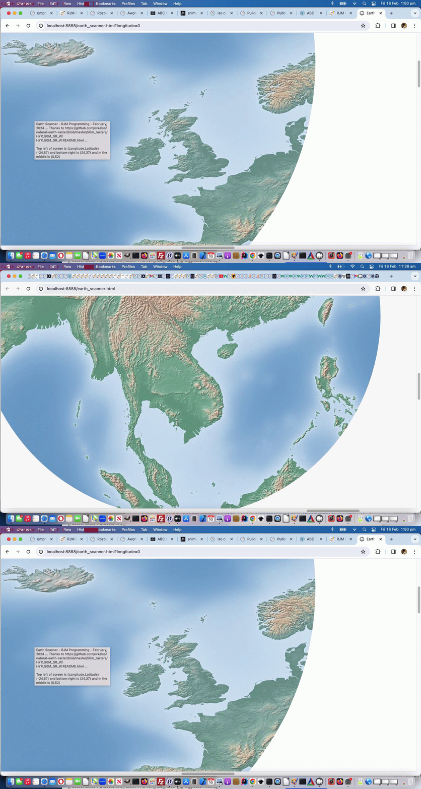
Today we’ve got for you a tutorial that takes bits and pieces from …
- “Just Javascript” (ie. no body element to speak of as you begin) … ref: Just Javascript Card Game iPhone Debugging Tutorial
- “CSS Property clip-path” … ref: Region Picker Area of Interest
- “GeoJson” especially regarding reverse engineering on the Mercator projection … ref: Google Chart Image Chart Map Chart GeoJson Onclick Tutorial
- “One Image Website” regarding scrolling and images bigger than screen … ref: One Image Website Scrolling Position Fix Tutorial
- “CSS keyframes Animation” … ref: CSS Grid Column Animation Tutorial
… so as to create a new “Earth Scanner” web application in what we like to think of as “the where of life” realms.
In essence this Earth Scanner is pretty simple, so below you can see a first draft, “holus bolus” …
<html>

<head>

<title>Earth Scanner - RJM Programming - February, 2024 ... Thanks to https://github.com/nvkelso/natural-earth-raster/blob/master/50m_rasters/HYP_50M_SR_W/HYP_50M_SR_W.README.html</title>

<style>

 #myimg {

   clip-path: circle(2% at 800px 700px);

   animation:mymove 5s infinite;

   -webkit-animation:mymove 5s infinite; /* Safari and Chrome */

}


@keyframes mymove

{

  0%   { clip-path: circle(2% at 0px 0px) }

  100% { clip-path: circle(16% at 140px 140px) }

}


@-webkit-keyframes mymove /* Safari and Chrome */

{

  0%   { clip-path: circle(2% at 0px 0px) }

  100% { clip-path: circle(16% at 140px 140px) }

}

</style>

<script type=text/javascript>

// Deemed unnecessary is ...

//  7%   { clip-path: circle(3% at 10px 10px) }

//  14%  { clip-path: circle(4% at 20px 20px) }

//  21%  { clip-path: circle(5% at 30px 30px) }

//  28%  { clip-path: circle(6% at 40px 40px) }

//  35%  { clip-path: circle(7% at 50px 50px) }

//  42%  { clip-path: circle(8% at 60px 60px) }

//  50%  { clip-path: circle(9% at 70px 70px) }

//  57%  { clip-path: circle(10% at 80px 80px) }

//  64%  { clip-path: circle(11% at 90px 90px) }

//  71%  { clip-path: circle(12% at 100px 100px) }

//  78%  { clip-path: circle(13% at 110px 110px) }

//  85%  { clip-path: circle(14% at 120px 120px) }

//  93%  { clip-path: circle(15% at 130px 130px) }


  var xp=0, yp=0, num=0;

  var fixkeys='<style> #myimg {  animation:mymove 5s infinite; -webkit-animation:mymove 5s infinite; } @keyframes mymove' + document.head.innerHTML.split('@keyframes mymove')[1].split('</style>')[0] + ' </style>';

  var screenlong=-9, screenlat=-9, askfor=null, enforcedlong=false, enforcedxp=-999;


  function scmove() {

    var longforce='-999', latforce='-999';

    if (screenlong < 0) {

      screenlong=eval(360 * screen.width / document.getElementById('myimg').width);

      screenlat=eval(180 * screen.height / document.getElementById('myimg').height);

      document.getElementById('myimg').onclick=function() {  askfor=prompt('Earth Scanner - RJM Programming - February, 2024 ... ' + String.fromCharCode(10) + 'Thanks to https://github.com/nvkelso/natural-earth-raster/blob/master/50m_rasters/HYP_50M_SR_W/HYP_50M_SR_W.README.html ... ' + String.fromCharCode(10) + 'Currently top left of screen is (Longitude,Latitude) ' + '(' + eval(-180 + xp * 360 / 100) + ',' + eval(90 - yp * 180 / 100) + ') and bottom right is (' + eval(-180 + screenlong + xp * 360 / 100) + ',' + eval(90 - screenlat - yp * 180 / 100) + ') and in the middle is (' + eval(-180 + eval(screenlong / 2) + xp * 360 / 100) + ',' + eval(90 - eval(screenlat / 2) - yp * 180 / 100) + ').' + String.fromCharCode(10) + 'Where do you want middle of screen to be in terms of Longitude,Latitude?', ''); };

    }

    //document.title="window.scrollTo(" + eval(xp * eval('' + document.getElementById('myimg').width) / 100) + "," + eval(yp * eval('' + document.getElementById('myimg').height) / 100) + ")";

    if (askfor != null) {

       if (askfor.replace('(','').replace(')','').indexOf(',') != -1) {

         longforce=askfor.replace('(','').replace(')','').split(',')[0];

         latforce=askfor.replace('(','').replace(')','').split(',')[1];

       } else if (askfor.replace('(','').replace(')','').indexOf(' ') != -1) {

         longforce=askfor.replace('(','').replace(')','').split(' ')[0];

         latforce=askfor.replace('(','').replace(')','').split(' ')[1];

       }

       //xp = eval(((eval(eval('' + longforce) + 180) / 360) * eval('' + document.getElementById('myimg').width) / 100) - 0 * eval(eval(screenlong / 720) * eval('' + document.getElementById('myimg').width) / 100));

       //yp = eval(((eval(90 - eval('' + latforce)) / 180) * eval('' + document.getElementById('myimg').height) / 100) + 0 * eval(eval(screenlat / 360) * eval('' + document.getElementById('myimg').height) / 100));

       xp = eval(eval(eval('' + longforce) - screenlong / 2 + 180) / 3.60); // * eval('' + document.getElementById('myimg').width) / 100) - 0 * eval(eval(screenlong / 720) * eval('' + document.getElementById('myimg').width) / 100));

       yp = eval(eval(90 - eval('' + latforce) - screenlat / 2) / 1.80); // * eval('' + document.getElementById('myimg').height) / 100) + 0 * eval(eval(screenlat / 360) * eval('' + document.getElementById('myimg').height) / 100));

       //alert('' + xp + ',' + yp + ' ... ' + "window.scrollTo(" + eval(xp * eval('' + document.getElementById('myimg').width) / 100) + "," + eval(yp * eval('' + document.getElementById('myimg').height) / 100) + ")");

       askfor=null;

       if (enforcedlong) {

          enforcedlong=false;

          enforcedxp=xp;

          //alert(xp + ' or ' + enforcedxp);

       }

    }

    eval("window.scrollTo(" + eval((enforcedxp > -990 ? enforcedxp : xp) * eval('' + document.getElementById('myimg').width) / 100) + "," + eval(yp * eval('' + document.getElementById('myimg').height) / 100) + ")");

    document.getElementById('myimg').title='Earth Scanner - RJM Programming - February, 2024 ... ' + 'Thanks to https://github.com/nvkelso/natural-earth-raster/blob/master/50m_rasters/HYP_50M_SR_W/HYP_50M_SR_W.README.html ... ' + String.fromCharCode(10) + String.fromCharCode(10) + 'Top left of screen is (Longitude,Latitude) ' + '(' + eval(-180 + (enforcedxp > -990 ? enforcedxp : xp) * 360 / 100) + ',' + eval(90 - yp * 180 / 100) + ') and bottom right is (' + eval(-180 + screenlong + (enforcedxp > -990 ? enforcedxp : xp) * 360 / 100) + ',' + eval(90 - screenlat - yp * 180 / 100) + ') and in the middle is (' + eval(-180 + eval(screenlong / 2) + (enforcedxp > -990 ? enforcedxp : xp) * 360 / 100) + ',' + eval(90 - eval(screenlat / 2) - yp * 180 / 100) + ')';

    document.title=document.getElementById('myimg').title; //'Top left of screen is (Longitude,Latitude) ' + '(' + eval(-180 + xp * 360 / 100) + ',' + eval(90 - yp * 180 / 100) + ') and bottom right is (' + eval(-180 + screenlong + (enforcedxp > -990 ? enforcedxp : xp) * 360 / 100) + ',' + eval(90 - screenlat - yp * 180 / 100) + ') and in the middle is (' + eval(-180 + eval(screenlong / 2) + (enforcedxp > -990 ? enforcedxp : xp) * 360 / 100) + ',' + eval(90 - eval(screenlat / 2) - yp * 180 / 100) + ')';

    if (xp < 95) {

      xp+=5;

    } else if (yp >= 95 && xp >= 95) {

      enforcedxp=-999;

      xp=0;

      yp=0;

    } else {

      yp+=5;

      xp=0;

    }

    var xdiff=eval((enforcedxp > -990 ? enforcedxp : xp) * eval('' + document.getElementById('myimg').width) / 100);

    var ydiff=eval(yp * eval('' + document.getElementById('myimg').height) / 100);

    var startkeys=fixkeys;

    var coords=fixkeys.split('px');

    for (var ic=0; ic<coords.length; ic+=2) {

      if (coords[ic].split(' ')[eval(-1 + coords[ic].split(' ').length)].indexOf('<') == -1) {

      //alert('' + xdiff + ',' + ydiff+ ',' + coords[ic].split(' ')[eval(-1 + coords[ic].split(' ').length)]);

      startkeys=startkeys.replace(' ' + coords[ic].split(' ')[eval(-1 + coords[ic].split(' ').length)] + 'px', ' ' + eval(xdiff + eval('' + coords[ic].split(' ')[eval(-1 + coords[ic].split(' ').length)])) + 'px');

      startkeys=startkeys.replace(' ' + coords[eval(1 + ic)].split(' ')[eval(-1 + coords[eval(1 + ic)].split(' ').length)] + 'px', ' ' + eval(ydiff + eval('' + coords[eval(1 + ic)].split(' ')[eval(-1 + coords[eval(1 + ic)].split(' ').length)])) + 'px');

      }

    }

    //alert(startkeys);

    document.getElementById('dstyle').innerHTML=startkeys; //.replace(/mymove/g, 'mymove' + num);

    num++;

  }


  setInterval(scmove, 5000);

  document.write("<img src='/HTMLCSS/HYP_50M_SR_W.jpg' id=myimg></img><div id=dstyle></div>");

  var latis=location.search.split('latitude=')[1] ? decodeURIComponent(location.search.split('latitude=')[1].split('&')[0]) : '';

  var longis=location.search.split('longitude=')[1] ? decodeURIComponent(location.search.split('longitude=')[1].split('&')[0]) : '';

  if (latis != '' && longis != '') {

    askfor='' + longis + ',' + latis;

  } else if (latis != '') {

    askfor='-168,' + latis;

  } else if (longis != '') {

    enforcedlong=true;

    askfor='' + longis + ',70';

  }

</script>

</head>

<body>

</body>

</html>
… with great thanks to this great resource as the crucial image in our

Please note using it, it does have onclick logic to specify …
- your own (longitude, latitude) to send the middle of the screen’s content to
- at the address bar …
https://www.rjmprogramming.com.au/HTMLCSS/earth_scanner.html?latitude=-33&longitude=151# Can center you around Sydney Australia

https://www.rjmprogramming.com.au/HTMLCSS/earth_scanner.html?latitude=0# Can take you, first up, on a tour around the equator in the middle of the screen

https://www.rjmprogramming.com.au/HTMLCSS/earth_scanner.html?longitude=0# Can take you, first up, on a tour down the zero meridian of longitude past London's Greenwich in the middle of the screen
If this was interesting you may be interested in this too.


 Menu
Menu


