|
Thanks to Wikipedia ...
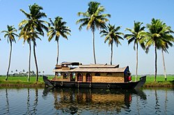
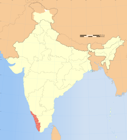
Kerala (/ˈkɛrələ/), often referred to as Keralam,[4] is a state in the south-west region of India on the Malabar coast. It was formed on 1 November 1956 as per the States Reorganisation Act by combining various Malayalam-speaking regions. Spread over 38,863 km2 (15,005 sq mi) it is bordered by Karnataka to the north and north east, Tamil Nadu to the east and south, and the Lakshadweep Sea to the west. With 33,387,677 inhabitants as per the 2011 census, Kerala is the twelfth largest state by population and is divided into 14 districts with the state capital being Thiruvananthapuram. Malayalam is the most widely spoken and official language of the state. The region was a prominent spice exporter from 3000 BCE to 3rd century. The Chera Dynasty was the first powerful kingdom based in Kerala, though it frequently struggled against attacks from the neighbouring Cholas and Pandyas. During the Chera period, Kerala remained an international spice trading center. Later, in the 15th century, the lucrative spice trade attracted Portuguese traders to Kerala, and eventually paved the way for the European colonisation of India. After independence, Travancore and Cochin joined the Republic of India and Travancore-Cochin was given the status of a state. Later, the state was formed in 1956 by merging the Malabar district, Travancore-Cochin (excluding four southern taluks), and the taluk of Kasargod, South Kanara. Kerala is the state with the lowest positive population growth rate in India (3.44%) and has a density of 860 people per km2. The state has the highest Human Development Index (HDI) (0.790) in the country according to the Human Development Report 2011.[3] It also has the highest literacy rate 93.19%, the highest life expectancy (Almost 77 years) and the highest sex ratio (as defined by number of women per 1000 men: 1,084 women per 1000 men) among all Indian states. Kerala has the lowest homicide rate among Indian states, for 2011 it was 1.1 per 100,000.[5] A survey in 2005 by Transparency International ranked it as the least corrupt state in the country. Kerala has witnessed significant emigration of its people, especially to the Gulf states during the Gulf Boom during the 1970s and early 1980s, and its economy depends significantly on remittances from a large Malayali expatriate community. Hinduism is practised by more than half of the population, followed by Islam and Christianity. The culture of the state traces its roots from 3rd century CE. It is a synthesis of Aryan and Dravidian cultures, developed over centuries under influences from other parts of India and abroad. Production of pepper and natural rubber contributes to a significant portion of the total national output. In the agricultural sector, coconut, tea, coffee, cashew and spices are important. The state's coastline extends for 595 kilometres (370 mi), and around 1.1 million people of the state are dependent on the fishery industry which contributes 3% of the state's income. The state's 145,704 kilometres (90,536 mi) of roads, constitute 4.2% of all Indian roadways. There are three existing and two proposed international airports. Waterways are also used for transportation. The state has the highest media exposure in India with newspapers publishing in nine different languages; mainly English and Malayalam. Kerala is an important tourist destination, with backwaters, beaches, Ayurvedic tourism, and tropical greenery among its major attractions. Contents | |||||||||||||||||||||||||||||||||||||||||||||||||||||||||||||||||||||||||||||||||||||||||||||


